I am, at last, picking up the outgoing 1840 brigade as it leaves the Thompson River post on the east bank of the North Thompson River, and follows its old trail along the south bank of the South Thompson River toward the place where Monte Creek flows in from the south.
According to James R. Gibson, author of the book, The Lifeline of the Oregon Territory; the Fraser-Columbia Brigade System, 1811-47 (Vancouver: UBC Press, 1997), this was the trail that the fur traders used until 1843.
It took only a few days to make this short trip through Monte Lake to Okanagan Lake.
Normally it took eight or so days for the brigades to make the journey south all the way to the Okanogan post, at the junction of the Okanogan River with the Columbia.
From the map above, you can see that the brigaders crossed the South Thompson River and rode east along its banks to Monte Creek.
The brigaders then waded across Monte Creek and rode along its east bank up the hills toward Monte Lake.
The photograph to the left shows the grassy, open pine woods they rode through.
In mid-summer this was hot and dry country, and even in late spring it would have been warm and sunny most of the times they made this journey south.
The fur traders followed the east bank of Monte Creek all the way to the lake at its head -- today's Monte Lake.
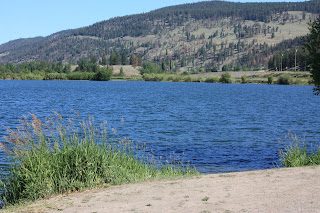
I n the photograph to the left and below, we are looking back from the shores of Monte Lake, at the place where the fur traders rode in from the Thompson's River post.
I
 n the photograph to the left and below, we are looking back from the shores of Monte Lake, at the place where the fur traders rode in from the Thompson's River post.
 We are looking north, from the east side of the lake where the actual brigade trail ran.
In the photograph below, we are looking south along the shores of Monte Lake, in the direction that the fur traders travelled to reach Okanagan Lake.
The brigaders must have made their first camp on the shores of this lake -- on Anderson's map this was called "Campement du Poulin."
My French dictionary does not tell me what the word 'poulin' means, but it could have referred to grouse or other chicken-like birds found here.
To the left and below is the part of the country that Anderson and other furtraders called "the Grande Prairie." He wrote of this place in later years, saying:

"...I may mention that there are in various portions of British Columbia large tracts of pasture land where the snow never accumulates. These tracts are generally broad valleys lying between high ridges of hills. There is one in particular, near the dividing watershed of the Columbia and the Thompson. It is called the Grande Prairie, and contains several thousands of acres of the most luxuriant pasture. The existence of these open tracts facilitates greatly the raising of large herds in their vicinity; so that in the event of unlooked for severity of the season they can at once be driven to abundant and unembarrassed pasture. I have in vain endeavored to account satisfactorily for this anomaly, and may possibly advert to the fact again before I conclude."
This quote comes from Anderson draft unpublished manuscript, "British Columbia," pp. 25-26, BCA.
Today's "Grande Prairie" surrounds the British Columbia town called Falkland.
A hundred and fifty years ago Anderson and other fur traders called the river that flowed through this valley the Salmon River.It is known by the same name today -- it is probably the Native name for the river.
Below are two more photos -- one of the flatlands north of Lake Okanagan, and one looking down the length of the lake from the west shore, where the old brigade trail ran.
These are views that every fur trader who rode up and down this trail enjoyed.
In this photo we are probably a little east of the place where the fur traders' trail led.
This is Swan Lake, a smaller lake to the east of the north end of Lake Okanagan.
The fur traders actually rode into the west side of the north end of Lake Okanagan and never saw this country.This is Swan Lake, a smaller lake to the east of the north end of Lake Okanagan.
But we are looking east, and the hills on the other side of the lake are similar or the same as the hills that the brigaders would have seen.
Below is the view of the fifty mile long Lake Okanagan from its north end, close to the place where the fur traders would have ridden in.
Below is the view of the fifty mile long Lake Okanagan from its north end, close to the place where the fur traders would have ridden in.


No comments:
Post a Comment